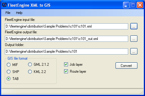
The viewer application allows you to easily link FleetEngine input and output and save it in a number of popular GIS formats. It requires that you have set parameter GISOutput before running FleetEngine.
File format can be chosen: TAB, SHP, MIF, KML or GML.
You need an actual GIS application to see the result. Several free ones are available: TatukGIS Viewer, ArcGIS Explorer, MapInfo ProViewer and many more.
If you choose KML as output format, you can use Google Earth for viewing. Please remember KML only works with geographic coordinates.
FeXmlConverterLib
FeXmlConverterLib is a .NET class library assembly which provides functionality to automate conversion of FE XML file to GIS tables, so you can add the same functionality as in the viewer to your own applications.
It exports class FeXmlConverter with two methods:
•void CreateGIS(bool aCreateJobsTable, bool aCreateRoutesTable, string aInputXmlPath, string aOutputXmlPath, string aOutputPath, TGISFormat gisFormat)
Works with xml files specified by aInputXmlPath and aOutputXmlPath
•void CreateGISFromString(bool aCreateJobsTable, bool aCreateRoutesTable, string aInputXml, string aOutputXml, string aOutputPath, TGISFormat gisFormat)
Works with xml strings contained in aInputXml and aOutputXml