The MakeNetwork.exe application (windows only) is used to import your own data into the format required by RW NetServer.
Click the "Select Input" button and navigate to a TAB, MIF, SHP or CGF file. More details on possible data sources.
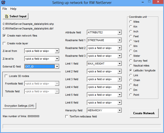
This will automatically update the setting for the second file with attribute information. The attribute file should be in one of these formats:
•DAT (TAB)
•MID (MIF)
•DBF 3 (SHP & CGF).
The application will also attempt to detect the coordinate unit from the chosen dataset. If your SHP file has a PRJ file present, it will be read too.
If you check "create node layer" a file is generated with all intersections, which you can open in your GIS. First record has node ID 1 etc. This can be used for your own internal control of node IDs.
Z-level from/to: These 2 numbers should be from -9 to 9 and is usually found in NavTeq and TomTom data (fields ELEVFROM and ELEVTO) to denote different elevation levels for street intersections in the network.
If you check the "locate 3D nodes", you should point to 2 fields with fromnode and tonode information. More details here.
Click here for details on encryption settings.
Additional fields:
•Attribute: Link attribute - see details here. You will have to pick a field even if you just want to do simple shortest path calculations with no oneway directions or any other special settings. In that case refer to any field in your dataset with all zero's.
•Roadname: The name of the road, which will be used in the generation of driving directions. There is no limit on the length of the text and you can even put in some HTML code, if certain street names should be marked (e.g. <B>Main Street</B>) in the final output. This can be used to highlight toll-roads etc. If you don't want to create driving directions, just skip this field. You will still be able to calculate distances and show routes on maps. Text fields for roadname settings should be in ASCII, ANSI or UTF-8 format (use UTF-8 if you want to generate GML2 output). UTF-16 is not supported. You can setup several fields for different languages if you like to. If your client uses UTF-16 (Java and C# do this), you plan to use non-ASCII characters and the array output format, we recommend that you replace those non-ASCII characters with a different sequence that can be replaced on the client side. Such that "å" could be stored as "/aa/" in your roadname field and then a search-and-replace is done in your code.
•Limit: These fields should hold an integer from 0-255. The integer is a limit in terms of max weight, width, height or whatever may be needed. A special bit pattern mode is also available. You can create 3 such limits at any time and you define how they should be used. 0 means no limit. See details here.
•Hierarchy: This field should hold a value from 1-5 for use with hierarchical routing. If you are using NavTeq data, use the field func_class. If you use TomTom data, select the field netbclass and tick the box below.
•External ID: This field can be an external ID, typically an integer with many digits, that is neverchanging and unique across the whole database (field ID in TomTom database, Link_ID in NavTeq database and TOID in ITN database). If you don't need to refer to the external ID in your application just skip the field.
If you use the TAB-format, it is a good idea to pack the table before creating the network, to make sure no records are marked for deletion.
Output will be generated in the same folder as the input files. A text file called network_report.txt will be generated in the same folder, if you select "create main network files".
Once the application has finished, you should move the generated *.bin files to a directory, which is accessible to RW NetServer. You will have to put each network in a separate directory. For the sake of performance this directory should be on a local harddisk.
Repeat the steps above for each network, you want to use with RW NetServer.
You should store a copy of the rwnetserver.lic file in the same folder as MakeNetwork application or you will only be able to compile networks with up to 3000 links.
A console version is also included (makenetwork_console.exe), which can be controlled by an INI file. See supplied sample.