Some street databases has special attributes for the most important streets, the ones being used as part of long routes. This will typically be motorways, but can also be ferries, bridges and some minor streets which are required to have a connected network.
The advantages of restricting routes to these more important streets are:
•Much faster point-2-point route calculations for long routes (function Route, RouteDyn and RouteList).
•Simpler routes, which doesn't make short-cuts via minor roads to make a long route a little shorter / faster.
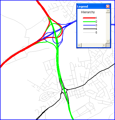
The map below shows an example from TeleAtlas Multinet data with 5 layers of importance (hierarchies):
RW NetServer uses a method where the calculation of the route is restricted to level 1..X as soon as level X has been reached on the route unless you are within a certain distance Y of the final target. Then additional levels are included in the search again.
For the algorithm to work properly the parameter Y has to be supplied for levels 2 to 5. Level 1 (the toplevel) is of course always included in the search. The best values for these parameters depend on the geometric properties of the network and how the hierarchy attribute has been setup.
If you have less than 5 levels in your datasource - 3 for instance - use levels 1, 2 and 3.
If you choose small parameters values, a smaller part of the network is considered when you get close to the target and this improves calculation speed. The downside is you risk not finding the target at all (!), because there are no major streets within the limits you have defined. The solution to this problem is to re-calculate without the hierarchy setting or just use a more relaxed setting (bigger parameters values). Such re-calculations are costly and when choosing parameters it is important to find a balance between normal, fast calculations and the slow re-calculations.
In the documentation for HierarchyLevelSet you can see suggestions for TeleAtlas and Navteq datasets and here is an example of how to use it:
rwcalc1.HierarchyLevelSet(145,90,40,7)
rwcalc1.hierarchy = true
dist = rwcalc1.Route(node1,node2)
if dist = -33 then
begin
rwcalc1.hierarchy = false
dist = rwcalc1.Route(node1,node2)
rwcalc1.hierarchy = true
end
The logic above is already part of the RouteList function internally.
See also functions HierarchyLevelSet and Hierarchy.